Creeks

Monday, August 23, 2021

Big Sur Drinking Fountains Revisited 2021


       Path to Big Redwood Drinking Fountain

The last time I visited Big Sur Fountains was in 2015.  To my surprise they had been tidied.  The weeds had been cut and rock clutter, eroding from the hills, removed.  Now, six years later, I wanted to see if the fountains had survived the elements, and the last few years of landslides, two of them being severe, causing Big Sur Highway (Hwy. 1) to close for extended periods of time.


Soda Springs* - The route to the fountains was from the south.  Soda Springs Fountain is a few miles north of Ragged Point.  It is easy to miss as it is tucked into a moist niche surrounded by vibrant Seep Monkey Flower and lavender hued Hedge Nettle.  The fountain is an excellent example of artful Conservation Corps craftsmanship.   (touch photo for larger image)


Only a handful of inches off busy Hwy. 1, the Soda Springs Fountain showed little change. (A sigh of relief)

The Drinking Fountains were built between 1933 and 1937 by the Civilian Conservation Corps, during construction of the Carmel-San Simeon Hwy.  A source of water was needed for thirsty motorists and their even thirstier automobiles.

Location information on the fountains may be found at  http://mycoastalcalifornia.blogspot.com/2014/08/big-sur-drinking-fountains-snippet-of.html


The Big Redwood Fountain is located at the beginning of a dense stand of Redwoods.  The trail to a Memorial Redwood Grove passes directly by the fountain.  Big Redwood is the most hidden of the five. The yellow blooming fennel was dense.


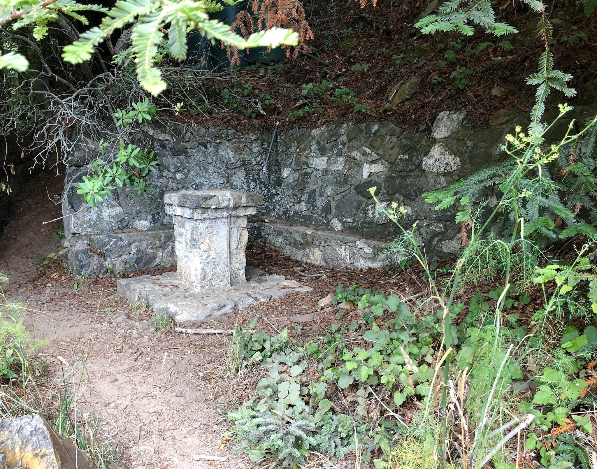
Big Redwood showed little change.  This artfully crafted fountain continues to stand the test of time.

Willow Creek/Seven Stairs Fountain* was very weedy.  Tenacious Poison Oak, Morning Glory, and California Sagebrush were overtaking the stonework.  Even the picnic table appeared in need of help. 


But, there is joy and beauty at this neglected historic fountain.  In the shadow of a giant rock, a tiny stream of spring water* trickled down a little wooden trough.  Unfortunately, this makeshift trickle of water is causing the stonework to deteriorate.  


This Morning drove up the coast, with friend Phoebe, for another look at WillowCreek/Seven Stairs fountain.  To my delight a weed eater had been at work; the weeds were gone.  


The picnic table perched on four rocks looked unstable.  Upon closer examination we found it sturdy as a rock.


Lucia Fountain,* located a few miles North of the Historic Lucia Lodge,** is set back from the Highway.  It is the only fountain with paved parking.  Aggressive non-native plants are encroaching on to the stonework.  A crumbling hillside may soon overtake the stonework to the north.  The fountain is being threatened by water seeping from a makeshift water supply.  The seepage has encouraged weeds to grow and stones to loosen and fall out of the fountain.  


Rigdon Fountain* - The fountain was originally named, The Elmer Rigdon Memorial Fountain after State Senator Rigdon who was instrumental in securing funding for building the highway.  The below photo was taken from across the highway.


It is impossible for me to write about the Big Sur Drinking Fountains without including a snipped of history.  June 27, 1937 - Grand Opening of the Carmel-San Simeon Highway - Dedication Ceremony for the Elmer Rigdon Memorial Fountain and park.  In the lower left hand corner of the historical photo can be seen a stone pedestal.  The very same pedestal can be seen in the lower right hand corner of the above current photo. 


The Park was weedy, but the stonework was in good condition.  Rigdon does not get much foot traffic as it is located on a curve with the only parking across the highway.  A speedy, death defying dash is needed to get to the fountain.  I did it once and swore I would never do it again.  

The Big Sur Fountains have survived 84 years, hopefully they will survive another 84.

 *water not potable

**   https://www.montereycountyweekly.com/blogs/news_blog/fire-destroys-restaurant-at-the-historic-lucia-lodge-in-big-sur/article_b9c7a1a8-fac4-11eb-8db2-2be90f18be62.html


Friday, November 27, 2015

Point Lobos State Natural Reserve

The jewel in the crown of California's State Park system - Point Lobos is famous for its breathtaking two mile coastline that offers to the visitor views of beautiful coves and mysterious caves, an abundance of spring wildflowers, nesting birds on offshore rocks, otters and seals, and dramatic Cypress trees precariously perched on rugged rock formations.  Point Lobos is a nature lovers paradise.
A United States Natural Landmark, Point Lobos is located about three miles south of Carmel on Highway One.  Hours are 8 to a 1/2 hour after sunset, fee $10, seniors $9.  A map with in-depth information on the reserve and the trails is available at the entrance kiosk for $2.  Trail maps can also be found at http://pointlobos.org/planning-your-visit/trail-maps 
After you enter the reserve, the first road on your right takes you to Whaler's Cove and Whalers Cabin Museum (above).  The Museum holds a wealth of historic information.  The abalone diver (below) is one of the fascinating artifacts found in the Cabin Museum which is staffed with friendly and informative docents.
The parking/picnic area, left side of photo, down the slight hill from the cabin, was the location the "Point Lobos Canning Co." where abalone was canned from 1899 - 1928.  (photo - Whale's Cove and distant Carmel Cove) 
Whaler's Cove is extremely popular with divers. 
The offshore waters are one of the richest underwater habitats in the world.  Scuba and free diving is by permit only - for reservations go to http://www.parks.ca.gov/?page_id=28353

Straight ahead from the entrance kiosk (.5mi.) is the Information Station (below) and parking area for five trails, South Shore, Sand Hill, Sea Lion Point, Cypress Grove, and North Shore.  
All but three of the 15 trails in the reserve are less than a mile.  The North Shore Trail is the longest at 1.4 miles one way; it is suggested for the more agile walker; a few trails are totally accessible.  Every trail leads to a scenic view.   (below - view from Sea Lion Pt. Trail)
Bird Island Trail (below), one of the premier trails in the reserve, is totally accessible.  Views from the trail include secluded coves, spring wildflowers, and bird rock which in the spring hosts thousands of nesting birds such as Brant Cormorant, American Oystercatcher, Black-crowned Night Heron, Black Oystercatcher, and Western Gull. 
The above photo of Bird Island which, in the springs is dense with nesting bids, was taken from the Bird Island Trail.  The trail is fully accessible, round trip, 1.4 miles.

Whale watching - Gray Whale - 40-50 ft. - 34-40 tons.  In December Gray Whales begin their migration to Mexico; their return trip begins in February.  Viewing is best when they head north, as the mother and calf hug the coast to avoid the killer whale.  Humpback Whale - 40-52 ft. - 30-50 tons -  summer through fall.  Blue Whale - 75 - 80 ft - 110 tons.  Occasionally from July through Sept. 

Point Lobos offers drama, beauty, solitude, and peace and is the Jewel in the State Parks Crown. 


Monday, June 8, 2015

Hetch Hetchy

Hetch Hetchy is the name of a valley, a reservoir, and a water system.  The valley is located northwest of Yosemite National Park.  Connecting Hetch Hetchy to coastal California is a 175 mile system that brings San Francisco and nearby municipalities their primary source of water and power.  John Muir, a naturalist and conservationist, with the support of the Sierra Club, fought a gallant, yet losing battle to protect Hetch Hetchy Valley from ruination by the city of San Francisco. 
 After the 1906 earthquake San Francisco was desperate for a reliable source of water and power.  In 1913 Congress passed an act authorizing construction of a dam.  The O'Shaughnessy Dam, named after the engineer who oversaw its construction, was completed in 1923.  Between 1935 and 1938 the dam was raised 85 ft to increase its capacity.  

Included in the construction was a 500 ft tunnel, cut through solid granite.  One must go over the dam and through the tunnel to reach the popular trail that leads to Wampa Falls.  I can testify the tunnel is dark and very wet, as the roof and walls drip continually.  The photo is not the best quality, but it does illustrate this fascinating tunnel.  The only way to avoid the pools of water is to walk close to the wall and hope for the best.  

Have no fear there is light at the end of the tunnel.
 The Tuolumne River, a primary source of the water for the reservoir, flows down Wampa Falls.  (photo, center left)  I did attempt the walk to Wampa, but due to a change in weather and the time of day, and facing a four hour drive over the death defying Hwy 49 to my night's lodging (I am not exaggerating),  I turned around.
 The reservoir is eight miles long; when full it has a capacity of 360,400 acre ft.  An acre foot is equivalent to 325,851 gallons.  Down stream, the three associated power plants produce 1.6 billion kilowatt hrs a year.   Now, be sure you are sitting down when you read this - To use the Hetch Hetchy Valley as a reservoir, San Francisco pays an annual fee, set by law in 1913, of $30,000.  (A one bedroom apartment in San Francisco goes for $2,500 a month or $30,000 a year.) 

The Sierra Club continues to support the restoration of the Valley.  Sierra Club founder John Muir called Hetch Hetch Valley,"a grand landscape garden, one of Nature's rarest and most precious mountain temples."

Map of the Hetch Hetchy project is from Wikipedia.


Tuesday, April 28, 2015

Big Sur Drinking Fountains Revisited

With Phoebe Adams as navigator and note taker, we headed north on Highway I to see if the current drought was affecting the Historic Fountains.  Much to our delight Soda Springs, the first fountain going north, (above Photo) was lush; spring water flowed cheerfully through the vegetation. The fountain actually sparkled; this little hidden roadside oasis had been cleaned of weeds and rock debris.   --  Link to original posting on The Big Sur Drinking Fountains  -    http://mycoastalcalifornia.blogspot.com/2014/08/big-sur-drinking-fountains-snippet-of.html

We only hesitated at Big Redwood, as it lacks water, and one must slosh through a wet area to reach the fountain remnant.   Big Redwood is the only fountain that is not directly on the road.
A surprise awaited us at Willow Creek/Seven Stairs - Spring water was flowing into a pool.  A benefactor had trimmed the weeds and connected the pipes (above photo).  Native plants were numerous.  The plant with the tiny white flowers is Thimble Berry.  The plant with the lavender flowers is Hedge Nettle.  The Willow Creek Fountain is seven steps above the road, has a great view and a picnic table that is patiently waiting for a picnic.
The Lucia Fountain had also been tidied.  Perhaps the Highway maintenance crew had adopted the fountains.  Spring Water was flowing into a culvert.  Yellow Seep Monkey-flower was a definite day brightener. 

We did not stop at the Rigdon Fountain, as it lacks water, and to reach it one must cross Highway One near a blind curve (no thank you).  We could see that it had been weeded and cleaned.

The historic fountain saga may yet have another chapter.  Originally there were six fountains; the missing fountain was thought to have disappeared in one of the many landslides.  On our way home, somewhere between Nepenthe, the famous Big Sur restaurant, and the Torre Canyon Bridge, I thought I saw fountain rock work.  To quote A. Schwarzenegger, "I'll be back!" 

Sunday, February 1, 2015

San Francisco Fisherman's Wharf Hostel


The San Francisco Fisherman's Wharf Hostel, housed in historic buildings on the grounds of Fort Mason, offers to travelers reasonably priced accommodations with million dollar views of the awe inspiring Golden Gate Bridge and the infamous island prison of Alcatraz. (Photo below)

Foot/bike paths lead from the Hostel to Ghirardelli Square, Maritime Park, Golden Gate Bridge, bike rentals, and public transportation. Once you arrive, I highly recommended not driving, as finding a parking space in the City is nearly impossible. 


Friendly front desk clerks have a wealth of information to share.  All you have to do is ask. Rates vary as to the number of individuals per room.   Private rooms range from $75 - $109.  The $40 room I was in held 8 females in 4 bunk beds.  Under each bunk were roomy storage compartments.  Be sure to bring a padlock.
Cafe Franco, the on-site eatery with a view of the bay, offers 3 meals a day plus a substantial complimentary breakfast that includes excellent coffee.  I can testify that Cafe Franco's hand made pizza was excellent. 
On the main floor was a spacious common room with comfortable seating and ample outlets for recharging electronic devises.  The shared kitchen, on the lower level, was large and well equipped, including refrigerators, freezers, storage shelves, and pots and pans of every imaginable size - everything one might need to prepare a meal, large or small. The three man in the photo were eating a stake dinner they had just prepared.

So very different from conventional lodging where the norm is not speaking to anyone.  I had conversations with a delightful, 20 year old male from Australia,  a vet's assistant from Great Briton, a professional biker from San Diego, a homesick young woman from China, and a retired couple from New Zealand that we're having the time of their lives.

The S. F. Fisherman's Hostel http://www.sfhostels.org/fishermans-wharf/rates
 offers more than a reasonably priced room and a complimentary breakfast.  It offers an adventure in lodging that I guarantee will be a memorable experience.  


Monday, September 1, 2014

Stenner Creek Bridge - A Snippet of California History


When I first saw the Stenner Creek Bridge I was amazed that such a marvelous example of 19th century engineering existed in San Luis Obispo County.  I assumed the old bridge was no longer in use, as the steel trestle was heavy with rust, until a lengthy freight train passed over my head.  I had to know more about this trestle bridge.

The year was 1889 - The Southern Pacific Railroad had reached as far south as Santa Margareta.  Ahead loomed the Santa Lucia Range of rolling hills with the steep Cuesta Grade.  A typical trip from San Luis Obispo to Templeton took eight hours over the grade, needless to say the railroad was eagerly anticipated.

Between 1893 and 1894 workers blasted 1,100,000 cubic yards of rock to create six tunnels, the longest 3,610 ft.  Crews worked 12 hour days, six days a week for $30 - $35 a month.

The final challenge for the Southern Pacific was crossing the broad expanse of Stenner Creek.  The Thompson Bridge Company of San Francisco was contracted to build a 950 foot trestle bridge, 80 feet above the creek bed; the bridge was designed and manufactured in Pittsburgh, Pennsylvania.
March 24, 1894, four cars laden with steel arrived in Templeton, fifty more loads were on the way.  Each part was numbered and ready to be assembled.  The foundations for this massive steel structure  were huge square granite piers as shown in the below photo.  The piers were mined from San Luis Mountain, also know as Madonna Mountain.  
 April 15, 1894, work on the bridge began.  Officials from Southern Pacific said, on May 5th a Southern Pacific Train would arrive in San Luis Obispo at 6:05 P.M.  A huge celebration was planned for the train's arrival.  May 3, the Stenner Creek Bridge had been completed, but 10,000 feet of track had yet to be laid.  Gangs of men went to work laying a hundred feet of track every five minutes.  Crowds of people watched in amazement. By evening the job was finished and the next day the Southern Pacific arrived in San Luis Obispo, on time.  The celebration lasted three days.
                     The Stenner Creek Bridge Has Been in Constant Use For 120 Years

Getting there: Stenner Creek Road is located on the East side of Hwy One in San Luis Obispo.  From the north take the first left turn after passing the California Men's Colony.  From the south turn right about one mile after passing Highland Drive.  Follow the road to the bridge


Wednesday, August 13, 2014

Big Sur Drinking Fountains - A Snippet of Coastal California History

Big Sur Drinking Fountains - Hidden in plain sight, along a twisting, scenic corridor of the Big Sur Highway (Hwy. 1), between Salmon Creek and Big Creek Bridge are five of the original six, artfully crafted, stone drinking fountains. (above photo - Soda Springs)

The Drinking Fountains were built by the Civilian Conservation Corps between 1933 and 1937 during construction of the Carmel - San Simeon Hwy.  A source of water was a necessity for thirsty motorists and their even thirstier automobiles as they traveled on this new remote, scenic highway.

             LOCATING THE FOUNTAINS
The Big Sur Drinking Fountains, from south to north are:  Soda Springs, Big Redwood, Willow Creek/Seven Stairs, Lucia, and Rigdon.  I can testify they can be tricky to locate. The five fountains are within a 26 mile stretch of highway beginning at the Monterey County line (mileage zero).  The county sign is located a few miles past Ragged Point on the ocean side of the Hwy.
Soda Springs is 3.8 miles after the county line, and about 1.5 miles after Salmon Creek Trail head. Pull off at Soda Springs trail head sign.  The fountain is located on the edge of the road, about 60 ft., south of the sign.
Big Redwood is 5.5 miles after the county line.  Pull off at Redwood Grove trail head, the sign is 80 feet in from the road.  The fountain is behind the trail sign.  The trail leads to the Nathaniel Owings Memorial Redwood Grove.   
Willow Creek/Seven Stairs - You have now driven about 11.5 miles.  The fountain is about 1/4 mile north of the impressive Willow Creek Bridge and is on a slight curve directly across from a large turnoff.  Seven stone steps lead to the fountain and picnic area which includes a picnic table.  A modest flow of spring water supports a colorful variety of native plants.  The view is spectacular.
Lucia is a tricky one.  The fountain is located in the center of a wide turnoff, between the Kirk Creek Bridge/Campground and Limekiln Bridge/State Park.  Distance between the bridges is 2 miles, more or less. The fountain is maybe 1/2 mile before Limekiln Bridge. The bridge is mile 21 from the county line.  Lucia is a great spot for whale watching.


Rigdon - Distance from co. line 26 miles or so.  The fountain is on a curve located mid way between Vicente Creek Bridge (mi. 25.8) and Big Creek Bridge (mi. 28) - distance between the bridges about 2 miles.  Across the road and south a tad, is a turnout.  Look for a curve with tall trees.  The Rigdon Fountain is a memorial to the late State Senator, Elmer Rigdon, who in 1922, secured funding for construction of the Hwy. 


In 1922, just after highway construction started, Senator Rigdon passed away.  In June 1937, as part of the opening ceremony for the new, scenic Carmel - San Simeon Highway, the Rigdon Drinking Fountain was dedicated.

Hidden in plain sight, five historic, hand crafted stone fountains, with ample places to sit and enjoy the view, await your visit.